
Grace: Weighing Water from Space and Its Global Impact
How the GRACE twin-satellite mission revolutionized hydrology by detecting invisible shifts in Earth's water, ice, and groundwater from orbit — and what its successor reveals about a drying planet.
Introduction: Gravity as a Measuring Instrument
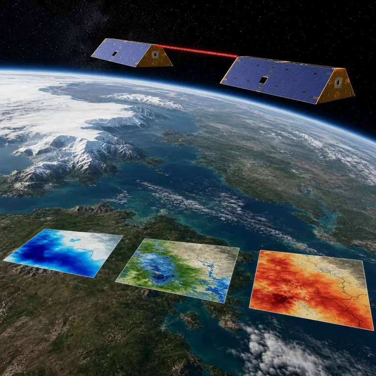
In March 2002, NASA and the German Aerospace Center launched two nearly identical satellites into low Earth orbit, separated by roughly 220 kilometers. They were not equipped with cameras. They carried no imaging spectrometers. Instead, the Gravity Recovery and Climate Experiment, known as GRACE, was built around a single extraordinary idea: that Earth’s gravitational field is not uniform, and that its subtle variations change as mass shifts across the planet’s surface. By precisely measuring the distance between the two satellites using a microwave ranging system accurate to within a micron — about one-hundredth the width of a human hair — scientists could calculate where mass was accumulating or disappearing below.
Water is mass. Ice is mass. Groundwater is a mass. When a drought drains an aquifer, the land beneath it loses mass. When monsoon rains saturate a river basin, the region gains it. GRACE could detect these changes from 450 kilometers above the surface, effectively weighing entire continents' worth of water without touching a single drop. The mission, which operated until 2017, produced one of the most consequential climate datasets in the history of Earth science.
What made GRACE so unusual was not merely its technical precision, but its conceptual inversion of how remote sensing had traditionally worked. Satellites had long been used to observe what was visible — ice extent, vegetation cover, ocean color, and urban sprawl. GRACE observed something that had no surface expression at all. An aquifer draining hundreds of meters below ground leaves no color change, no shadow, no thermal signature. It leaves only a faint and measurable reduction in gravitational pull. To build a mission around detecting that signal required a leap of scientific imagination that, in retrospect, seems obvious only because it worked so spectacularly well.
What GRACE Revealed That No One Expected
The findings from GRACE’s fifteen-year operational life overturned assumptions that hydrologists had held for decades. One of the most alarming discoveries came from the Central Valley of California, where GRACE detected a dramatic and accelerating loss of groundwater between 2003 and 2010, long before state regulators had reliable data from conventional well measurements. The satellite revealed that the region was losing roughly 31 cubic kilometers of groundwater in just seven years, a volume equivalent to nearly 25 million Olympic swimming pools. This finding, published in Geophysical Research Letters in 2011 by Jay Famiglietti and colleagues at the University of California, Irvine, directly influenced California’s eventual Sustainable Groundwater Management Act of 2014. It is one of the cleaner examples in recent history of satellite data translating directly into legislative action.
GRACE also transformed the understanding of ice sheet dynamics. Before the mission, estimates of Greenland and Antarctic ice mass loss were considered highly uncertain, subject to wide error bars that made policy projections difficult to anchor. The satellites provided monthly snapshots of gravitational change across both ice sheets, revealing that Greenland alone was losing approximately 286 billion tons of ice per year between 2002 and 2016, a figure that has since accelerated. These measurements became foundational inputs for sea level rise projections used by the Intergovernmental Panel on Climate Change. The precision of the GRACE record gave researchers something they had not previously had: a long-term, consistent, and physically grounded baseline against which future change could be measured.
Perhaps less expected were the findings about terrestrial water storage in the tropics. GRACE detected that the Amazon basin functions as a massive seasonal water reservoir, swelling and contracting by hundreds of cubic kilometers across wet and dry seasons. This dynamic had been theorized but never directly quantified at the basin scale. The mission also identified long-term drying trends in the Tigris-Euphrates basin across Turkey, Syria, Iraq, and Iran, a region already under severe geopolitical stress over water access. Between 2003 and 2009, the basin lost approximately 144 cubic kilometers of total water storage, much of it from groundwater, according to research published in Water Resources Research in 2013. That finding arrived as the Syrian civil war was approaching its catastrophic peak, a conflict in which water scarcity and agricultural collapse played documented roles in driving rural displacement toward cities. The satellite had not predicted the war, but it had measured one of its underlying pressures with a clarity that ground-based observation could not match.
The Gap, the Successor, and the Problem of Scientific Continuity
GRACE’s instruments gradually degraded, and the mission officially ended in October 2017 when the satellites' batteries failed beyond repair. This created an immediate scientific crisis. Researchers who had built monitoring systems, drought indices, and climate models around continuous GRACE data suddenly faced an eleven-month gap before the successor mission became operational. For a dataset that had become foundational to global water security monitoring, even a year of missing observations carried real consequences for the models and early warning systems that depended on it.
GRACE-FO, for Follow-On, launched in May 2018 as a joint effort between NASA and the German Research Centre for Geosciences. It carried an upgraded laser-ranging interferometer alongside the traditional microwave system, achieving ranging precision roughly 20 times greater than its predecessor. This laser system, developed in part at the Albert Einstein Institute in Hannover, Germany, was the first demonstration of laser interferometry in space for geodetic purposes, serving as a technology pathfinder for future gravitational wave detection and geodesy missions. The engineering challenge it represented was considerable: maintaining a coherent laser link between two spacecraft moving at approximately 27,000 kilometers per hour, separated by 220 kilometers, while accounting for the thermal, vibrational, and gravitational perturbations that constantly act on both vehicles.
The eleven-month data gap between GRACE and GRACE-FO became a subject of scientific study. Researchers used statistical methods and machine learning algorithms to reconstruct what likely occurred during the gap by bridging data from other satellite systems and ground-based monitoring networks. The exercise was partially successful, but it also exposed a broader vulnerability in Earth observation science: the absence of redundancy in critical monitoring infrastructure. A single mission, however capable, leaves the scientific record brittle. If GRACE-FO were to fail before a third-generation successor was ready, the consequences for global water monitoring would be severe. The scientific community has increasingly argued for overlapping mission architectures, in which successor satellites are launched while their predecessors remain functional, precisely to avoid the kind of continuity crisis that the 2017 to 2018 gap illustrated.
A Drying Planet Measured in Microns
GRACE-FO continues to operate as of 2025, and its data stream has grown only more urgent. Recent analyses drawing on the combined GRACE and GRACE-FO record have documented accelerating groundwater depletion across the North China Plain, the Indus basin in Pakistan and India, the Iranian plateau, and the High Plains Aquifer beneath the central United States. A 2023 study published in Nature Water by Scott Jasechko and colleagues found that groundwater levels in wells globally have declined at an accelerating rate since the 1980s, a trend that GRACE-FO data independently corroborate through gravitational signatures. The convergence of well measurements and satellite gravimetry, two entirely different methods of observation that arrive at the same conclusion, lends the finding unusual scientific weight.
The mission has also become an unexpected tool in humanitarian early warning systems. By detecting anomalous water storage deficits months before surface drought conditions become visible to optical satellites or human observers, GRACE-FO data now feeds into famine early warning systems used by the United States Agency for International Development. Regions showing sustained gravitational water loss correlate with agricultural stress that can be flagged well ahead of crop failure, giving aid organizations and governments a longer window in which to respond. This application was not part of the original mission design. It emerged from the data itself, as researchers realized that the gravitational signal of groundwater loss was not just a scientific curiosity but an operationally useful early indicator of humanitarian risk.
There is something philosophically striking about this trajectory. A mission conceived to answer questions in geodesy and hydrology has become a tool for anticipating food crises. The path from measuring the distance between two satellites to flagging famine risk in the Horn of Africa is not obvious, but it is real and illustrates how foundational scientific infrastructure can generate applications its designers never anticipated. This is not an argument for serendipity over planning. It is an argument for investing in observation systems that are precise, consistent, and long-lived enough to reveal patterns that only become visible across time.
Conclusion: Listening to the Invisible
The broader legacy of the GRACE program is a fundamental reframing of how Earth observation works. Rather than photographing what is visible, the mission listens to what is invisible, the gravitational whisper of water moving beneath soil, rock, and ice. It is a reminder that some of the most consequential measurements in planetary science are not images of surfaces but calculations derived from the imperceptible flexing of space itself between two small machines orbiting in formation.
The water crisis unfolding across much of the inhabited world is not a projection of the future. It is a present condition, documented in gravitational data collected daily by two satellites that most people have never heard of. Aquifers that took thousands of years to fill are being drawn down in decades. Ice sheets that stabilized sea levels for millennia are shedding mass at rates without precedent in the instrumental record. These changes are not hypothetical. They have been weighed, measured, and published. The question that remains is not whether the data is real, but whether the institutions and political systems that depend on stable water supplies will act on it with anything approaching the precision with which it was gathered.
GRACE and its successor have given humanity an extraordinary gift: the ability to see, in near real time, how the planet’s water is moving and where it is disappearing. What is done with that knowledge is a different kind of problem, one that no satellite can solve.
Sources & Further Reading
- Famiglietti, J.S. et al. Satellites Measure Recent Rates of Groundwater Depletion in California's Central Valley. Geophysical Research Letters, 2011. https://agupubs.onlinelibrary.wiley.com/doi/10.1029/2010GL046442
- Longley, P. et al. The GRACE Mission: Overview and Early Results. NASA/DLR, 2002. https://grace.jpl.nasa.gov
- Jasechko, S. et al. Global Groundwater Wells at Risk of Running Dry. Nature Water, 2023. https://www.nature.com/articles/s44221-023-00030-7
- Landerer, F.W. et al. Extending the Global Mass Change Data Record: GRACE Follow-On Instrument and Science Data Performance. Geophysical Research Letters, 2020. https://agupubs.onlinelibrary.wiley.com/doi/10.1029/2020GL088306