
Speleothems: Earth's Hidden Climate Archives in Caves
Speleothems — cave formations like stalactites and stalagmites — are now recognized as some of Earth's most precise climate archives, encoding centuries of atmospheric, hydrological, and even volcanic history in their layered calcite rings.
Stone Records Hidden Underground
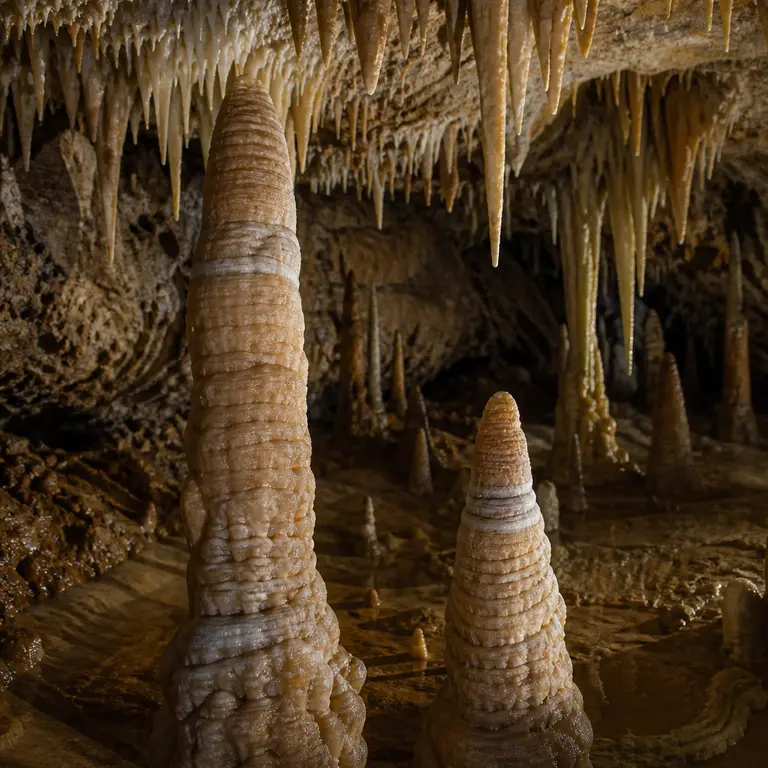
Deep inside limestone caves on every inhabited continent, a slow and silent process has been recording Earth’s climate history with extraordinary precision. Speleothems — the collective term for cave formations including stalactites, stalagmites, flowstones, and cave coral — grow by depositing thin layers of calcite or aragonite as mineral-rich groundwater seeps through bedrock and evaporates underground. Each layer, sometimes no thicker than a human hair, encodes chemical information about the rainfall, temperature, vegetation, and atmospheric conditions that existed at the time of its formation.
For decades, speleothems were studied primarily as geological curiosities or tourist attractions. That changed in the 1990s and early 2000s when paleoclimatologists began applying uranium-thorium radiometric dating to cave formations with a precision previously impossible. The method works because uranium dissolves readily in water while thorium does not, meaning that freshly deposited calcite contains uranium but virtually no thorium. As time passes, uranium decays into thorium at a known rate, and measuring the ratio between the two isotopes gives scientists an age for the layer, accurate to within a few decades, even for samples hundreds of thousands of years old. Unlike tree rings, which only extend back a few thousand years, or ice cores, which require polar conditions to preserve their layered records, speleothems can preserve continuous climate records spanning hundreds of thousands of years — and they exist in tropical, temperate, and arid regions where other proxies simply do not survive.
The field accelerated dramatically when the SISAL (Speleothem Isotopes Synthesis and Analysis) database began coordinating global speleothem records. By 2023, SISAL had cataloged data from over 700 cave sites across 71 countries, making it one of the most geographically comprehensive paleoclimate archives in existence. The database allows researchers to cross-reference records from opposite sides of the planet, revealing how climate events that appear local in one archive become globally synchronized when viewed through the combined lens of dozens of cave records.
The Chemistry of Memory
What makes speleothems so scientifically valuable is the chemical fidelity of their layers. As water percolates through soil and rock before entering a cave, it picks up dissolved carbon dioxide from plant roots and soil microbes, forming weak carbonic acid that dissolves calcium carbonate from the surrounding limestone. When this water drips into the cave and loses carbon dioxide to the cave atmosphere, calcite precipitates out — and with it, a snapshot of the world above.
The ratio of oxygen isotopes — specifically oxygen-18 to oxygen-16 — within each calcite layer reflects the temperature and source of precipitation at the time of deposition. Heavier rainfall, warmer ocean surface temperatures, and shifts in monsoon intensity all leave distinct isotopic fingerprints. The logic is elegant: water molecules containing the lighter oxygen-16 isotope evaporate more readily from ocean surfaces and travel farther inland before precipitating, while water molecules carrying heavier oxygen-18 fall closer to the coast. By reading the ratios of these isotopes across thousands of annual layers, scientists can reconstruct the strength and geographic reach of monsoon systems that operated long before any human observer recorded them.
Carbon isotope ratios add a second independent channel of information, recording changes in vegetation above the cave. Plants that use the C3 photosynthetic pathway — which includes most trees and shrubs — process carbon differently from C4 plants such as tropical grasses and many crops. A landscape transition from dense forest to open savanna, therefore, produces a measurable shift in the carbon-13 content of the calcite layers deposited below. This means that a single stalagmite can simultaneously record both the climate that drove a vegetation change and the ecological response to that change, encoded in adjacent isotopic signals within the same thin band of stone.
Trace elements add further layers of information. Magnesium and strontium concentrations track how long water spends in contact with bedrock before entering the cave — a proxy for drought intensity, since water moves more slowly through rock during dry periods and picks up more of these elements along the way. Phosphorus spikes have been linked to periods of increased biological activity in the soil above, sometimes corresponding to agricultural intensification or forest clearance by human populations. In 2019, researchers analyzing a stalagmite from Belize identified chemical signatures consistent with the prolonged droughts now associated with the collapse of Classic Maya civilization between roughly 800 and 1000 CE, corroborating archaeological evidence with sub-decadal resolution. The cave had been recording the death of a civilization one drip at a time, entirely without human awareness.
Volcanic Eruptions and Nuclear Fallout Preserved in Stone
One of the more surprising recent discoveries is that speleothems record not only gradual climatic shifts but also discrete catastrophic events. Large volcanic eruptions inject sulfur dioxide into the stratosphere, which oxidizes to sulfate aerosols and temporarily cools the planet by reflecting incoming solar radiation. These cooling pulses produce detectable oxygen isotope anomalies in speleothem layers — anomalies that can be matched to known eruption dates with remarkable accuracy. The cave, in this sense, functions as a seismograph for atmospheric disturbances, registering shocks originating thousands of kilometers away.
A 2022 study published in Nature Communications examined a stalagmite from a cave in northern Italy and identified a sharp isotopic excursion corresponding to the 536 CE mystery event — a period of severe atmospheric cooling now attributed to a massive volcanic eruption, possibly in Iceland, that triggered crop failures and famine across the Northern Hemisphere. The Byzantine historian Procopius described the sun as giving light without brightness during this period, and tree-ring records from Scandinavia and Siberia confirm a dramatic suppression of growth consistent with reduced solar input. The speleothem record supported and refined existing ice core data, narrowing the timing of the eruption and its climatic aftermath with a precision that neither archive could achieve alone. When multiple independent archives converge on the same event, the confidence in the reconstruction increases substantially, and the Italian stalagmite provided exactly that kind of corroboration.
Perhaps more unexpectedly, some speleothems have been found to record the era of atmospheric nuclear testing in the mid-20th century. Bomb-pulse radiocarbon — the spike in carbon-14 produced by above-ground nuclear detonations between 1952 and 1963 — has been detected in fast-growing cave formations from sites in China, Europe, and the Americas. The nuclear testing programs of the United States and the Soviet Union, conducted in remote deserts and on Pacific atolls, left a chemical signature that penetrated the soil, entered the groundwater, and was faithfully incorporated into the calcite of growing stalagmites around the world. This provides both a precise chronological marker for dating recent speleothem layers and a demonstration that cave systems are more intimately connected to surface atmospheric chemistry than previously assumed. The Cold War, it turns out, is written in stone.
Modern Applications and Conservation Concerns
The practical applications of speleothem science extend well beyond academic paleoclimatology. Water resource managers in semi-arid regions are using speleothem records to reconstruct the natural variability of monsoon rainfall over millennia, providing a baseline against which to measure present-day anomalies. Without such long-term baselines, it is difficult to determine whether a modern drought represents a temporary fluctuation within normal variability or a genuinely unprecedented departure from historical norms. In the Middle East, speleothems from Soreq Cave in Israel have produced one of the most detailed records of Levantine precipitation over the past 250,000 years, informing contemporary debates about regional water security in one of the world’s most politically contested watersheds.
In 2024, a research team from the University of Melbourne published findings from a stalagmite collected in a cave in southeastern Australia, revealing that the region experienced a prolonged multi-century drought between approximately 1000 and 1260 CE — a period with no written historical record in Australia but now reconstructed with annual resolution from the cave formation. The research has significant implications for understanding the long-term drought cycles that underpin modern bushfire risk, and it raises questions about how Indigenous Australian communities adapted to and survived a climatic stress event of that magnitude and duration.
Despite their scientific value, speleothems face serious threats. Tourism, vandalism, and changes in cave hydrology driven by surface land use and climate change all affect the rate and chemistry of formation. Even the carbon dioxide exhaled by visitors alters the cave atmosphere and can affect ongoing deposition. A single human breath introduces more carbon dioxide into a small cave chamber than would naturally accumulate over hours, and the cumulative effect of thousands of daily visitors in popular tourist caves can measurably change the chemistry of actively growing formations. Several major cave systems, including Carlsbad Caverns in New Mexico and Jenolan Caves in Australia, have implemented strict visitor protocols in recent years specifically to protect active speleothem growth. Some formations have been physically damaged by vandals or inadvertently broken by visitors who did not realize that a stalactite growing at one cubic centimeter per century cannot simply be replaced.
The irony is acute: the very climate disruption that speleothems help scientists document is also altering the conditions under which new formations grow. In some caves, reduced infiltration due to surface drought is slowing or halting active deposition. In others, increased surface temperatures are changing the isotopic composition of precipitation in ways that may complicate future interpretations of the record. Scientists studying present-day cave chemistry are finding that the relationship between surface climate and cave calcite, painstakingly calibrated over decades of research, may need recalibration for a warmer world.
A Planetary Diary Written in Stone
Speleothems occupy an unusual position in the landscape of scientific tools. They are not instruments that humans designed or deployed. They are natural archives that formed and accumulated over geological time through processes entirely indifferent to human existence, and they happened to preserve information that turns out to be extraordinarily relevant to understanding the planet that humans now inhabit and are rapidly altering. The fact that a drip of groundwater falling in a dark cave in Belize 1,200 years ago could tell a modern scientist about the rainfall patterns that contributed to the fall of an entire civilization is a reminder that the Earth has been keeping records far longer and far more faithfully than any human institution.
The coming decades will likely see speleothem science expand in several directions simultaneously. Advances in mass spectrometry are enabling the extraction of isotopic information from ever-smaller samples, potentially allowing researchers to read seasonal or even monthly climate signals from formations that were previously too thin to analyze. Machine learning tools are being applied to large speleothem datasets to identify patterns that human analysts might overlook. And as the SISAL database continues to grow, the global picture of past climate variability will become increasingly detailed, providing the long-term context that climate modelers need to test and refine their projections.
Speleothems will continue to grow — or not — indifferent to human concerns. But for the scientists who read them, these stone formations represent something extraordinary: a planetary diary written in chemistry, hidden underground for millennia, and now finally being read by the species whose future may depend on understanding what it says.
Sources & Further Reading
- Fairchild, I.J. and Baker, A. Speleothem Science: From Process to Past Environments. Wiley-Blackwell, 2012.
- Comas-Bru, L. et al. SISAL (Speleothem Isotopes Synthesis and Analysis Database): a global resource to document oxygen and carbon isotope records from speleothems. Earth System Science Data, 2020. https://doi.org/10.5194/essd-12-2579-2020
- Turner, B.L. et al. Drought and the Classic Maya Collapse. Science, 2012. https://www.science.org
- Winter, A. et al. Speleothem record of the 536 CE volcanic event and its climatic aftermath. Nature Communications, 2022.