The Satellite That Listens to Dying Forests Scream
A new generation of hyperspectral satellites can detect tree stress, disease, and death weeks before it becomes visible to the human eye — transforming how scientists monitor forest collapse in real time.
Forests Have a Color Language We Are Only Beginning to Read
When a tree begins to die, it does not simply turn brown and fall. Long before visible decay sets in, the chemistry of its leaves shifts, altering how it reflects light across hundreds of wavelengths invisible to the naked eye. Chlorophyll concentrations drop. Water content in leaf tissue changes. Stress-related pigments accumulate. These shifts produce what scientists call a spectral signature — a fingerprint of distress encoded in reflected light that no human eye can perceive, but that satellites increasingly can.
This silent language of dying trees has existed for as long as forests have covered the Earth. What has changed is our ability to read it. For centuries, foresters relied on what they could see with their own eyes: the yellowing of needles, the emergence of beetles from bark, the slumping of the canopy after a dry summer. These visible signs are real, but they are late. By the time a tree shows symptoms that a trained observer can identify on foot or from a low-flying aircraft, the biological processes driving its decline may have been underway for weeks or months. The damage, in many cases, is already done.
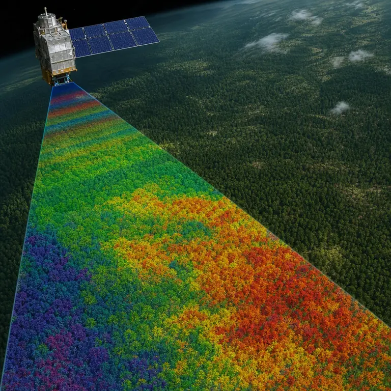
Hyperspectral remote sensing, a technology originally developed for military reconnaissance and mineral prospecting, is now being repurposed to read these dying signals from orbit. Unlike standard cameras that capture only three broad bands of light — red, green, and blue — hyperspectral sensors divide the electromagnetic spectrum into hundreds of narrow, contiguous bands. The result is less a photograph and more a chemical portrait of everything below. Each pixel in a hyperspectral image contains not a color but a spectrum, a curve of reflected energy that encodes information about the physical and biochemical properties of whatever surface produced it.
The implications for global forest monitoring are profound. Scientists can now detect bark beetle infestations in conifer forests weeks before visible browning begins, identify drought stress in tropical canopies before leaf drop occurs, and map the spread of fungal pathogens across landscapes at a resolution of a few meters per pixel. In an era of accelerating climate disruption, when forest ecosystems face simultaneous and compounding threats from heat, drought, invasive species, and disease, the ability to detect stress early and at scale is not merely scientifically interesting. It may be one of the most consequential tools available for managing what remains of the planet’s forested land.
The Satellites Doing the Listening
The European Space Agency’s DESIS instrument aboard the International Space Station and the German Aerospace Center’s EnMAP satellite, launched in April 2022, represent the current frontier of this technology. EnMAP — the Environmental Mapping and Analysis Program — carries a hyperspectral imager that captures 244 spectral bands spanning 420 to 2450 nanometers, covering the visible, near-infrared, and shortwave-infrared portions of the spectrum. Its 30-meter-per-pixel spatial resolution allows it to distinguish individual forest patches across entire continents in a single overpass. That wavelength range is significant because different biochemical processes leave their marks at different points along the spectrum. Chlorophyll absorbs strongly in the red portion of visible light. Water in leaf tissue absorbs in the near-infrared. Cellulose and lignin, the structural compounds of wood, have absorption features in the shortwave infrared. A sensor that captures all of these regions simultaneously can read multiple physiological processes simultaneously, as a physician reading a panel of blood tests can assess the health of several organ systems in a single review.
NASA’s forthcoming Surface Biology and Geology mission, previously known as HyspIRI, is designed to extend this capability even further, with revisit times short enough to track rapid ecological change week by week. The mission is designed not only to monitor vegetation but to integrate forest health signals with measurements of soil composition, coastal water quality, and geological surface properties, creating a unified view of Earth’s biological and physical surface. Meanwhile, commercial operators, including Pixxel, an Indian startup, launched a constellation of hyperspectral nanosatellites in 2023 with the explicit goal of providing near-daily hyperspectral coverage of the entire Earth’s surface — a cadence that would make continuous, global forest health monitoring economically viable for the first time.
What makes these instruments particularly powerful is their ability to detect specific biochemical compounds remotely. Lignin, cellulose, nitrogen, and water content in vegetation all have known spectral absorption features. Algorithms trained on field measurements can invert these spectral signals to estimate canopy chemistry with surprising accuracy, essentially performing a chemical analysis of millions of trees simultaneously from 600 kilometers above the ground. The pipeline from raw spectral data to biological interpretation has matured considerably over the past decade, driven by advances in machine learning that allow models to find patterns in high-dimensional spectral datasets that no human analyst could identify manually. The satellite is the instrument, but the algorithm is increasingly the scientist.
What the Data Is Already Revealing
The results emerging from early hyperspectral forest surveys are unsettling in their detail. A 2021 study published in Nature Plants used airborne hyperspectral data over the Amazon basin to show that trees experiencing hydraulic stress — a condition in which drought causes air bubbles to form in water-conducting tissue — could be identified spectrally up to 5 weeks before any visible wilting. The study estimated that stress signatures were detectable across roughly 17 percent of the sampled Amazon canopy during the severe 2015-2016 El Niño drought, a proportion that ground-based surveys had dramatically underestimated. The finding reframes the scale of that drought’s biological impact. What appeared from the ground to be a bad but survivable dry season was, at the physiological level, a widespread and measurable crisis playing out silently across millions of hectares of one of the most biodiverse ecosystems on Earth.
In European forests, hyperspectral analysis has been used to track the spread of Ips typographus, the European spruce bark beetle, across central Europe with a precision that traditional aerial surveys cannot match. Between 2018 and 2020, bark beetle outbreaks destroyed more than 100,000 hectares of spruce forest in the Czech Republic alone — an ecological catastrophe that hyperspectral early-warning systems might have allowed forest managers to respond to far more rapidly. The beetle itself is not the only cause of the destruction. Warming temperatures have extended the insect’s breeding season, allowed it to survive winters that once kept its populations in check, and simultaneously weakened the trees it attacks by reducing the resin pressure that constitutes the spruce’s primary chemical defense. Hyperspectral monitoring can detect the early stages of that weakening before the beetles arrive in force, offering a window for intervention that conventional observation methods cannot provide.
Perhaps most strikingly, researchers at the University of Zurich demonstrated in 2022 that hyperspectral data could distinguish between tree species experiencing different types of stress — drought, pest attack, or fungal infection — based on subtle differences in their spectral profiles. This specificity means that a single satellite overpass can potentially generate a map not just of where forests are stressed, but of what is stressing them and how severely. That level of diagnostic resolution transforms hyperspectral data from a monitoring tool into something closer to a triage system, one capable of directing limited management resources toward the areas of highest risk with a precision that no previous remote sensing technology has offered.
The Limits of Listening from Above
Hyperspectral forest monitoring is not without its complications. Cloud cover remains a persistent obstacle, particularly over tropical forests where the ecological stakes are highest and where cloud-free imagery can be difficult to obtain for weeks at a time. Tropical forests sit beneath some of the most persistently overcast skies on Earth, and the regions of highest biodiversity and ecological sensitivity are often the same regions where obtaining usable optical imagery is most difficult. Radar-based sensors can penetrate cloud cover, but they measure forest structure rather than chemistry, and combining the two data streams is not always straightforward. Increasing satellite revisit frequency improves the odds of catching a cloud-free window, but it does not eliminate the problem.
The algorithms that translate spectral signals into biological meaning require extensive ground-truth calibration and can perform poorly when applied to forest types or species assemblages that differ significantly from those used in the training datasets. A model calibrated on temperate European conifers may not transfer reliably to the mixed broadleaf forests of West Africa or the dipterocarp forests of Borneo. Building the training datasets needed to extend these models globally requires sustained investment in field measurement campaigns across dozens of countries and forest types — work that is expensive, logistically demanding, and dependent on international scientific cooperation that is not always forthcoming.
There is also the question of what to do with the information once it exists. Detecting that a million hectares of boreal forest is entering drought stress is scientifically valuable, but translating that detection into effective management intervention requires institutional capacity, funding, and political will that many of the countries with the most vulnerable forests lack. Critics of the technology argue that the satellite data can outpace the human systems designed to act on it, creating a gap between knowledge and response that the technology itself cannot bridge. In some contexts, the provision of ever more precise ecological distress signals without a corresponding investment in the governance and management infrastructure needed to act on them may produce not better outcomes but more precisely documented failures.
Nevertheless, the momentum behind hyperspectral forest monitoring continues to accelerate. The Global Ecosystem Dynamics Investigation instrument aboard the International Space Station, which measures forest vertical structure using lidar, is increasingly being fused with hyperspectral data to create three-dimensional chemical portraits of forest canopies — combining the where with the what in ways that neither technology could achieve alone. As commercial hyperspectral constellations mature and the cost of spectral data falls, the prospect of a continuously updated, planet-wide forest health map is moving from theoretical aspiration toward operational reality.
Conclusion
The forests have been sending signals for as long as they have existed. Every stressed tree, every beetle-infested stand, every drought-stricken canopy has been broadcasting its condition in wavelengths of reflected light that carry more biological information than any ground survey could capture. For most of human history, we lacked the instruments to receive those signals. For a briefer period, we had instruments but not the computational tools to interpret what they collected. Now, for the first time, the combination of orbital sensors, machine learning algorithms, and growing archives of calibration data is bringing that information within reach.
What humanity chooses to do with that information remains an open and urgent question. The technology is advancing faster than the institutions designed to use it, and the forests most in need of monitoring are often located in places where those institutions are weakest. But the scientific foundation is now solid enough that ignorance can no longer serve as an excuse. The spectral signatures are there, legible in the data streams flowing down from orbit, waiting to be read by anyone willing to look. The color language of dying forests is slowly and imperfectly becoming a language we can understand. The harder question is whether understanding it will be enough to change what we do next.
Sources & Further Reading
- Asner, G.P. et al. Progressive forest canopy water loss during the 2012–2015 California drought. Proceedings of the National Academy of Sciences, 2016. https://doi.org/10.1073/pnas.1523397113
- Berger, K. et al. Crop nitrogen monitoring with simulated Sentinel-2 data and a machine learning approach. Remote Sensing of Environment, 2020. https://doi.org/10.1016/j.rse.2020.111800
- European Space Agency. EnMAP Mission Overview. ESA Earth Online, 2022. https://earth.esa.int/eogateway/missions/enmap
- Sendall, K.M. et al. Hyperspectral remote sensing of foliar nitrogen content. New Phytologist, 2021.