
Revolutionizing Underwater Archaeology: Satellites at Sea
How synthetic aperture radar and multispectral satellite imaging are quietly revolutionizing underwater archaeology, revealing submerged Bronze Age trade routes and lost fleets without a single dive.
 Watch on YouTube
 Watch on Rumble
Introduction: Archaeology’s Most Inaccessible Archive
For most of human history, the seafloor has been archaeology’s most inaccessible archive. Wooden hulls dissolve over centuries, iron corrodes into unrecognizable masses, and the sheer cost of underwater excavation has left the vast majority of the estimated three million shipwrecks on the world’s ocean floors completely unstudied. Marine archaeologists have long operated under a paradox: the ocean preserves certain materials extraordinarily well, sealing objects in low-oxygen sediment for millennia, yet accessing those objects requires resources so substantial that only a tiny fraction of known sites have ever been systematically investigated. That equation is beginning to change, not through better submarines or more advanced diving equipment, but through satellites orbiting hundreds of kilometers above the ocean’s surface.
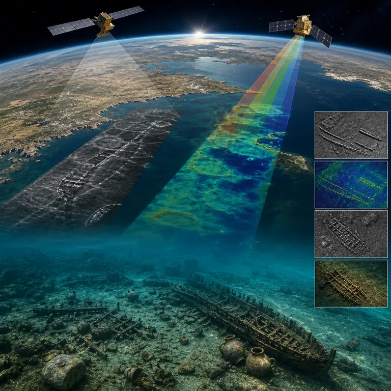
Since roughly 2019, a convergence of satellite technologies, including multispectral imaging, synthetic aperture radar, and high-resolution bathymetric mapping derived from space-based altimetry, has enabled archaeologists to identify previously unknown shipwreck sites in shallow coastal waters without ever entering the water. The results have been startling. In the Mediterranean alone, researchers using data from the European Space Agency’s Sentinel-2 constellation have identified dozens of anomalies in water as deep as 40 meters that, upon subsequent diving verification, correspond to ancient vessel remains, amphora fields, and cargo scatters dating as far back as the Bronze Age. What was once a discipline defined by its physical limitations is now being reshaped by data flowing down from orbit, and the implications extend well beyond any single discovery.
The technique is not magic. It exploits a fundamental property of shallow, clear water: sunlight penetrates to depths of roughly 25 to 40 meters in the Mediterranean and Caribbean, and objects on the seafloor reflect slightly different spectral signatures depending on their composition. A dense scatter of ancient ceramic amphorae, for example, reflects light differently than bare sand or seagrass. Multispectral satellites like Sentinel-2, which capture imagery across 13 spectral bands at 10-meter resolution, can detect those subtle differences when image analysts or machine learning algorithms know what patterns to look for. The science is grounded in physics that has been understood for decades. What is new is the combination of satellite resolution, data accessibility, and analytical sophistication that has finally made the approach viable for routine archaeological prospection.
The Bronze Age Trade Routes Emerging from Data
One of the most consequential applications of this technology came in 2022 and 2023, when a collaboration between the Hellenic Ephorate of Underwater Antiquities and researchers at the University of Southampton used Sentinel-2 data to survey a 400-square-kilometer stretch of the Aegean Sea between the islands of Chios and the Turkish coast. The region was historically significant: ancient texts and prior excavations had suggested it was a major Bronze Age and Classical-period shipping corridor, one of the arteries through which grain, olive oil, wine, copper, and tin moved between the civilizations of the eastern Mediterranean. But a systematic survey of the area had never been possible due to cost and the sheer scale of the search zone. A traditional acoustic or visual survey of that area would have required months of ship time and a budget well beyond the reach of most research institutions.
The satellite survey identified 11 previously unrecorded anomalies across the survey zone. Subsequent diving expeditions confirmed that seven of these corresponded to actual archaeological sites, including two amphora scatters tentatively dated to the 4th century BCE and one site containing what appear to be stone anchors of a type associated with Late Bronze Age Levantine seafaring, roughly 1400 to 1200 BCE. Stone anchors of this kind have been found at only a handful of sites globally, and their presence in the northern Aegean corridor adds a data point to ongoing debates about the geographic reach of Bronze Age maritime trade networks. The implications are significant: these sites, had they been found through conventional survey methods, would have required years of ship time and hundreds of thousands of dollars in funding. The satellite survey cost a fraction of that and was completed in a matter of weeks.
This approach is not entirely without precedent. Satellite remote sensing has been used in terrestrial archaeology since the 1970s, most famously to detect buried Roman roads in Britain and hidden Mayan cities beneath the Guatemalan jungle canopy using LiDAR. Corona spy satellite imagery from the Cold War era, declassified in the 1990s, revealed thousands of previously unknown archaeological sites across the Middle East by showing landscape features that have since been destroyed by agriculture and urban development. But extending these methods to underwater environments is genuinely new, and refining the algorithms needed to distinguish archaeological targets from natural seafloor features remains an active and competitive area of research. The underwater context introduces complications that terrestrial remote sensing does not face, including water-column distortion, variable turbidity, and the way light scatters differently at different depths, all of which must be accounted for in any rigorous analytical workflow.
The Role of Machine Learning and the Limits of the Method
Identifying a candidate shipwreck site in satellite imagery is not a task that can be fully automated, at least not yet. The spectral signatures of archaeological sites overlap considerably with those of natural features: rocky outcrops, seagrass beds, and sand ripples can all produce anomalies that resemble amphora fields or hull remains. A dense bed of Posidonia oceanica, the dominant seagrass of the Mediterranean, can cast spectral shadows that resemble the scatter pattern of ceramic cargo. For this reason, the most productive current workflows combine automated anomaly detection using convolutional neural networks trained on confirmed wreck sites with expert human review, a division of labor in which the machine handles scale and the human handles ambiguity.
A 2023 paper published in the Journal of Archaeological Science by researchers at the University of Cadiz described training a deep learning model on a dataset of 47 confirmed shallow-water wreck sites in Spanish territorial waters and then applying it to unsurveyed areas of the Gulf of Cadiz. The model flagged 23 candidate sites, of which 9 were subsequently confirmed as archaeological in nature through diving verification. That is a false-positive rate that would be frustrating in many scientific contexts, but it is considered remarkably efficient in underwater archaeology, where the alternative is essentially random searching across vast, featureless-seeming seabeds. The researchers also noted that several of the false positives, though not archaeological, identified geologically interesting features that had not previously been mapped, suggesting that the methodology generates useful knowledge even when it does not find what it is looking for.
The method has clear geographical limits that deserve honest acknowledgment. It works best in shallow, clear, low-turbidity water with minimal kelp or dense seagrass cover. The murky, nutrient-rich waters of the North Sea or the Baltic, where thousands of historically significant wrecks are known to exist, including vessels from the Viking Age, the Hanseatic trade era, and the major naval conflicts of the 17th and 18th centuries, are largely opaque to optical satellite sensors. Light simply does not penetrate far enough to illuminate the seafloor in any usable way. In those environments, researchers are experimenting with synthetic aperture radar, which can detect subtle surface-roughness anomalies caused by underwater structures interacting with tidal currents, but this method is far less mature and has yielded fewer confirmed results. The Baltic, in particular, represents a frustrating gap: its cold, low-salinity water preserves organic materials, including wood and rope, with extraordinary fidelity, making its wrecks among the most scientifically valuable in the world, yet the very conditions that make it so productive for preservation also make it nearly invisible to current satellite sensors.
Implications for Heritage Protection and Future Research
Beyond pure discovery, satellite-based wreck detection has a potentially transformative role in heritage protection, a dimension of the technology that has received less public attention than the discovery angle but may ultimately prove more consequential. Illegal salvage of ancient shipwrecks is a significant and growing problem across the Mediterranean, the South China Sea, and the Caribbean. The proliferation of affordable recreational diving equipment, combined with online markets for antiquities and the relative ease of evading enforcement in international or poorly monitored coastal waters, has made looting a persistent threat to the underwater archaeological record. Looted wrecks permanently lose their archaeological context: the spatial relationships between objects, which tell archaeologists about cargo organization, trade networks, shipboard social hierarchies, and the material culture of daily seafaring life, are destroyed the moment objects are moved from their resting positions.
Satellite monitoring offers a way to watch known wreck sites for disturbance at a scale and frequency that no patrol vessel or dive inspection program could match. High-resolution commercial satellites, including those operated by Maxar Technologies and Planet Labs, can now image specific ocean coordinates at resolutions of 30 to 50 centimeters and revisit those sites daily or even more frequently. Researchers at the Woods Hole Oceanographic Institution have proposed a systematic monitoring protocol in which known shallow-water wreck sites in high-risk areas are placed on automated alert systems that flag any change in the seafloor signature between successive satellite passes. A before-and-after comparison of spectral data could, in principle, detect the disturbance caused by a salvage operation within 24 to 48 hours of its occurrence, giving authorities at least a chance of responding before evidence is entirely removed.
The technology also intersects with a broader and genuinely democratic shift in how archaeological survey is funded and organized. Traditional underwater excavation requires institutional backing, research vessels, certified technical divers, and years of permitting from national maritime authorities. The process is slow, expensive, and gatekept by access to infrastructure that most researchers in the developing world simply lack. A satellite survey can be conducted from a university office using freely available Sentinel-2 data from ESA’s Copernicus Open Access Hub by a researcher with appropriate training in remote sensing analysis and access to open-source image processing software. Several universities have already begun incorporating this methodology into graduate archaeology programs, treating it as a core competency rather than a specialist niche. Citizen science projects are beginning to explore whether trained volunteers can assist in reviewing flagged anomalies at scale, much as platforms like Galaxy Zoo have mobilized public participation in astronomical image classification.
What remains genuinely uncertain is the method's ultimate depth ceiling. Current optical satellite techniques are largely limited to water shallower than 40 to 50 meters, which represents only a narrow band of the world’s maritime archaeological record. The majority of historically significant deep-water wrecks, including those from the major naval engagements of World War II in the Pacific and Atlantic, as well as ancient vessels that sank in open ocean crossings far from any coast, remain entirely beyond the reach of any satellite sensor currently in orbit. Whether next-generation satellite lidar systems, which use pulsed laser light to penetrate water to greater depths than passive optical sensors can, will eventually extend the method’s reach into the 60 to 100 meter range remains a question researchers are actively pursuing but have not yet answered. Early airborne lidar bathymetry systems have demonstrated penetration to around 50 meters in ideal conditions, and scaling that capability to satellite altitude remains a significant engineering challenge.
Conclusion: The Orbital View of Sunken Civilizations
For now, the technology has already accomplished something genuinely remarkable. It has turned the orbital vantage point of an Earth observation satellite, a tool designed primarily for monitoring land use, weather systems, and military installations, into an archaeological instrument capable of finding the physical remains of civilizations that sank beneath the waves two thousand years before the first telescope was built. The three million wrecks estimated to lie on the world’s ocean floors represent an archive of human activity spanning the entire history of seafaring, from the earliest reed boats of the Nile Delta to the steel hulls of the 20th century. Most of that archive has never been read.
The satellite cannot read it all. The method has real limits that honest researchers are careful to acknowledge. But it has already demonstrated that the ratio of known to unknown in underwater archaeology is far more skewed toward the unknown than anyone had the tools to appreciate before. Every confirmed site found through orbital imagery represents not just a discovery but a proof of concept: the sky, it turns out, is one of the most productive places from which to study the sea. As sensor technology improves, as machine learning models are trained on larger datasets of confirmed sites, and as the methodology spreads to research communities that previously lacked access to it, the pace of discovery is likely to accelerate. The seafloor’s long status as archaeology’s most inaccessible archive is, slowly but measurably, coming to an end.
Sources & Further Reading
- Agrafiotis, P., Skarlatos, D., Forbes, T., et al. Detecting Underwater Archaeological Sites Using Satellite Imagery. Journal of Cultural Heritage, 2020. https://www.sciencedirect.com/science/article/pii/S1296207419305096
- Blondel, P. and Murton, B.J. Handbook of Seafloor Sonar Imagery. Wiley-Praxis, 1997.
- European Space Agency. Copernicus Sentinel-2 Mission Overview. ESA, 2023. https://sentinel.esa.int/web/sentinel/missions/sentinel-2
- Mackie, E., Davis, M., et al. Machine Learning Applied to Satellite Detection of Submerged Archaeological Sites in the Gulf of Cadiz. Journal of Archaeological Science, 2023.